The National Hurricane Center (NHC) issued a tropical storm warning Monday, Aug. 31, covering Port Bolivar in Galveston County and areas eastward along the coast into Louisiana.
The warning does not include the cities of Houston or Galveston, but the system is forecast to push heavy rain across the Clear Lake area. Friendswood, Webster, Seabrook, Nassau Bay and Clear Lake Shores all fall within the broader rainfall threat zone, according to Houston Public Media.
The system, designated Potential Tropical Cyclone Five by the NHC, was previously tracked as Invest 97L. As of the 10 a.m. advisory Monday, it sat about 130 miles south of Morgan City, Louisiana, and about 230 miles southeast of Port Arthur, Texas. Maximum sustained winds were near 35 mph with higher gusts.
The NHC gave the system an 80% chance of becoming a tropical storm within 48 hours. If it strengthens, it would be named Edouard.
Rainfall and flooding
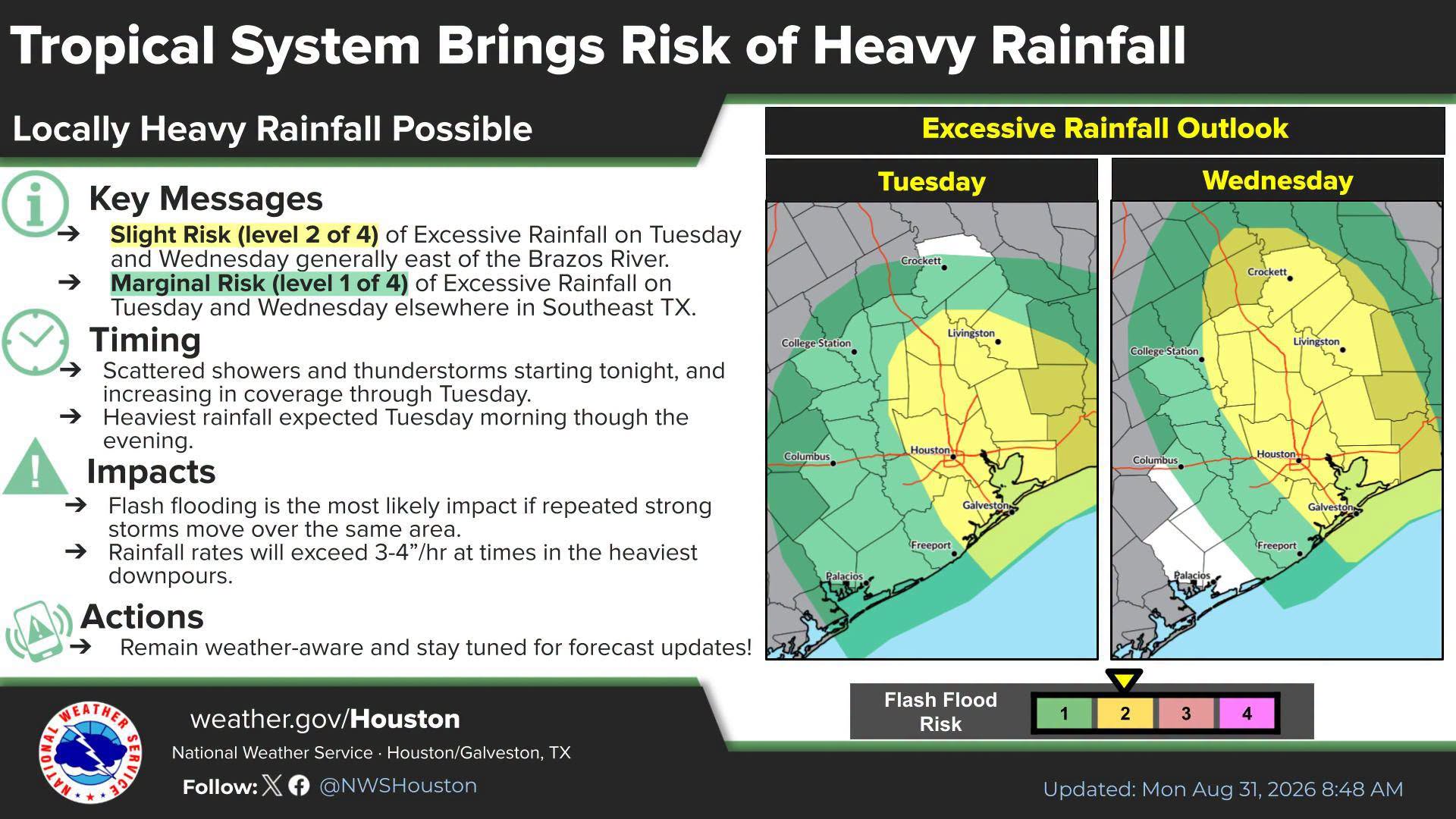
Scattered thunderstorms are expected to begin Monday night, with heavier storms building throughout Tuesday, Sept. 1. The NHC forecast 3 to 6 inches of rain for parts of the upper Texas coast inland through east-central Texas, with isolated totals reaching 9 inches.
The National Weather Service (NWS) warned that rainfall rates could exceed 3 to 4 inches per hour during the heaviest downpours. Houston could see up to 3 inches and Galveston up to 4 inches, according to NWS forecasts.
A flood watch is in effect from Monday night through Wednesday morning for Coastal Harris, Inland Harris, Coastal Galveston, Inland Galveston, Galveston Island, Bolivar Peninsula, Chambers, Montgomery and several other southeast Texas counties, FOX 26 Houston reported.
Parts of southeast Texas, including Houston, face a slight risk for excessive rainfall on Tuesday and Wednesday, according to NOAA's Weather Prediction Center.
Wind threat remains low
Galveston has a 17% chance of tropical storm force winds, and Houston has a 9% chance. Port Arthur and Beaumont face higher odds at 46% and 31%.
"For those folks further inland, metro area and northward we are looking more of a rainfall impact," NWS meteorologist Brian Kyle told Houston Public Media.
The NHC also warned of storm surge of 1 to 3 feet above ground from High Island, Texas, to the Vermilion/Iberia Parish Line in Louisiana if peak surge coincides with high tide.
The NHC's next complete advisory was scheduled for 4 p.m. Monday. Residents can track updates at hurricanes.gov and weather.gov/hgx.